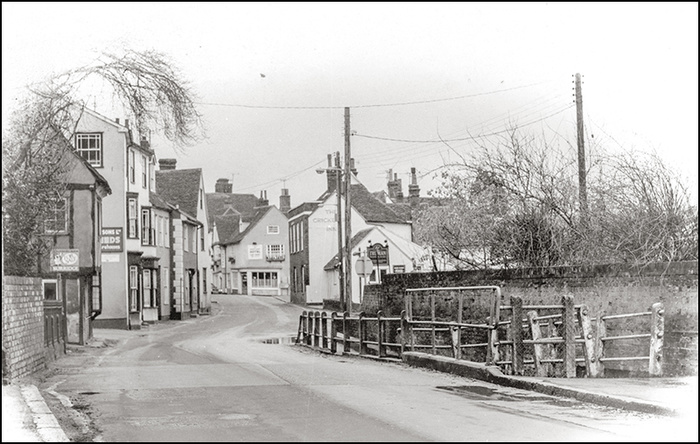
Hares Bridge
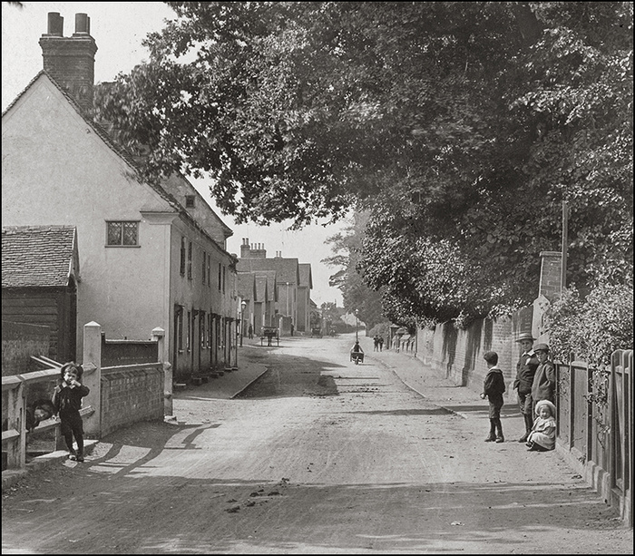
View of West Street from Hares Bridge. (Photo courtesy Doug Judd).
HARES BRIDGE is where the old main Colchester Road, Stane Street, crosses Robin's Brook.
It was called Hares Breg in 1525, Heres Brydge in 1567 and Hares Bridge from 1698 up to 1890 when Beaumont used it in his book, 'History of Coggeshall'. However, when the Ordnance Survey mapped the town for the first edition map of 1875, they decided to drop the 's' and call it Hare Bridge and so it has remained on the maps ever since.
Ignore the maps - it's Hares Bridge!
The name derives from a family name - Walter Hares who was granted a house and a meadow here by the lord of the manor in 1399.
Hares Bridge looking east towards Coggeshall centre.
Robins Brook can be seen in the plate just as it enters a culvert on the right associated with the Gravel Mill which used to stand here on the south side of West Street and spanned the brook. The mill was big, 130 feet long and 24 wide and was on 3 floors. It is surprising that Robin's Brook was ever strong enough to power a mill, but it does seem to have been the case - in fact there were other mills on the brook, just upstream near the ford at Robinsbridge Road, and at Tye Mill, where the brook meets the old course of the river now called the back ditch.
Until about 1800 the water which issued from the Church Pond (near Vane Lane) flowed as a brook down Church Street and joined Robin's Brook at Hares Bridge. This whole area was once very marshy, excavations made during remodelling work in 1989 showed wooden piles had been driven into the ground and a timber trackway laid on top, while gravel had been tipped over the site to raise the ground and allow houses to be built.
The Unmentionable Field
From the other direction a less savoury stream deposited its contents into Robin's Brook at Hares Bridge - the West Street Foulway. This open sewer ran from a field in West Street whose name Beaumont. the Coggeshall historian, could not bring himself to name - in 1890 he called it 'unmentionable'. The Tythe Schedule of 1854 was also reluctant to name the field properly, calling it 'Gutter Field'. To find its proper name we have to go back to 1734 when people were a little less embarrassed about bodily functions and it is named as bold as brass, 'Pissing Gutter Field'. Almost a hundred years earlier in 1639 the field appears as Pyssingne Gutter'(Cock Meadow is appropriately next door!). The Pissing Gutter must have run past Paycockes house which is perhaps why in his will of 1518 Thomas Paycocke left £40 for the maintenance of the 'foulways in West Street from Hares Bridge to Pissing Gutter Field'. Presumably he had paid to keep the foulway clear during his time in the house and wanted the practice to continue to the benefit of all.
An intriguing memory from Roderick Miller which suggests that the foulway may have been in a conduit and survived until recent times; 'I recall that immediately outside Swinbourne's office entrance near Pissing Gutter some workmen (perhaps the GPO?) discovered under the footpath a tunnel made of some form of tiles/flat rocks They only had a look and did not go too far as they were worried it may collapse on them My Mother was Secretary there at the time (1962'ish) and I saw the hole. There is still or was when last I saw it, a dip in the footpath where it had been back-filled.'
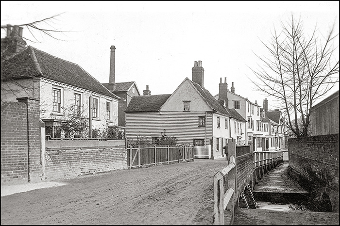
Close up showing the spillway at Hares Bridge
The Hares Bridge Spillway
When Robins brook flooded (as it often did) this spillway carried the floodwater across the Gravel and into a leet alongside (it's still there) which passed under Bridge Street and the iron foundry and emptied into the back ditch. The leet may have been built to supply the foundry, perhaps to drive a bellows or a hammer. The shambles, a market where meat was butchered and sold, was once on the north side of the Gravel so it is also possible that the leet is somehow connected with that.
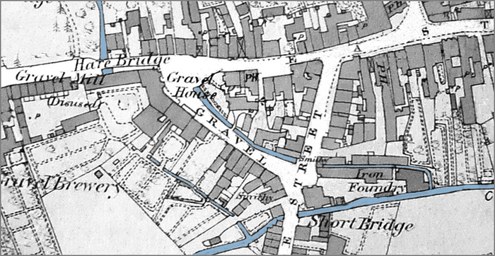
Map of 1875 showing Hare(s) Bridge, the Gravel Mill, the spillway and the leet running alonside The Gravel.
Gravel House was completely destroyed by fire in 1897.
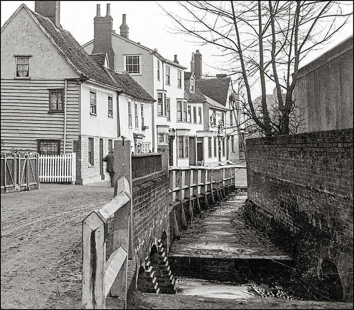
Hares Bridge in the 1980's showing the footbridge over the spillway.
In my time (1950's & 60's) and up until the late 1980's a raised footpath ran along and above the spillway which allowed pedestrians to cross Robins Brook without walking in the road. All this was cleared away in 1989 when the road was widened, pavements laid and the culvert enlarged as part of a flood protection scheme which made the spillway (allegedly) redundant. A garden in memory of Brian Tebbutt now occupies part of the site and the nearby houses called Culvert Place commemorate some of this history.
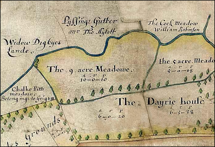
A map of 1639 showing 'Pyssinge Gutter (and Cock Meadow)'[ERO D/DOp P1]
Comments
 By Jenny Cole: My father purchased this row of cottages in the early 1950’s, extended the nearest one in the photo and we moved in around 1952 ish! They were known as Vicarage Cottages but then just became .. West Street. Very happy memories of my time there. By Roderic John Miller: As kids in the 50/60 there would be a moorhen's nest (Morkies) under the footpath and we would catch decent sized eels there also. By Roderic John Miller: THE ADAM BROTHERS USED TO LIVE IN THIS ROW They were both punters and collectors of antiques (Queen Vic's wedding cake a piece of) up to late 60's One year they went thru the card at Royal Ascot bar a second. By Geraldine spencer: I lived in 19 West St.just down from the Ladhams twins.The Gurtons owned the cottages then.My father worked at the International Stores driving the van. This was in the 50s/60s.